
Rocky Mountain National Park
Rocky Mountain National Park is one of the gems of the National Park Service and Colorado. The park encompasses about 415 square miles and is a short trip to the north west of Denver. Most people seem to stay in Estes Park when they visit RMNP, which is just east of one of the most popular entrances to the park, Beaver Meadows. Estes Park has become a tourist trap over the years, as would be expected, and has the traffic to go with it. The town does offer many options for staying the night, including the Stanley Hotel from Steven King’s The Shining. Being the outdoor nuts that we are, we totally forgot to stop by and see it though… We wanted to see everything we possibly could in the park with the time that we had.

The particular days that we were there were pretty unique. There were raging forest fires on the north end of the park and at elevation, the snow was still deep from the blizzard we had flown and driven through a couple days earlier. Because of these conditions, and the fact that the temperature was rising dramatically from day to day, we got to experience the park with and without snow, although at the highest spots snow is always around.


Once entering the park, we immediately headed for the highest point we could find, the Rainbow Curve Lookout on Trail Ridge Road. Trail Ridge Road spans the park from east to west, travels through the alpine tundra and tops 12,000 feet. It is the highest through road in Colorado and the highest paved road that crosses the continental divide. Driving Trail Ridge Road is one of the biggest attractions to visitors of the park for obvious reasons, so it is pretty safe and is mostly lined with guardrails on the steep side. It’s still a bit precarious to people like us from the east coast as our first experience driving through real mountains, especially once we got above the tree line, which was a first for us.
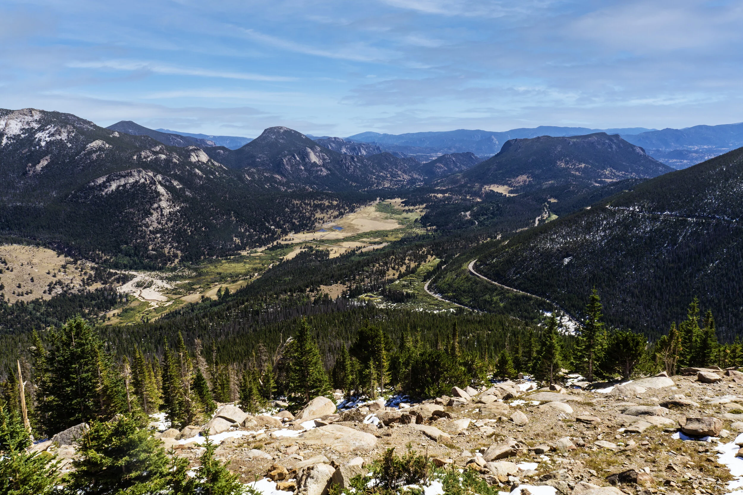
Once we arrived at Rainbow Curve we found that Trail Ridge Road was closed from that point forward. At the time, we didn’t know if it was because of fire or snow. Later we found out it was snow. We actually didn’t see much smoke in the park even though one of the fires was just north of Trail Ridge.

Rainbow Curve Lookout is still quite a beautiful spot to look over Hidden Valley below, along with the surrounding mountains. It was a popular spot given that it was the turnaround point with the rest of the road closed, but wasn’t terribly crowded.


There are chipmunks everywhere around the parking area that will come right up to you. Those little buggers are quick, but once and in while you get lucky and snap a good picture of one.

Since traveling any further on Trail Ridge Road was out, we decided to head back down to another one of the more popular spots in the park, Bear Lake. It is considered an alpine lake and sits at around 9,500 feet. There are numerous trails around the lake ranging from green to black. The trails are well traveled and well maintained.

Bear Lake


After Bear Lake we headed back to our condo for supper and to prepare for our stargazing adventure. Estes Park is full of nice condos perfect for weekend trips. We had a nice stream that we could hear from our balcony and even were greeted by an elk bugling across the water when we arrived.
Rocky Mountain National Park never closes, so with it’s remoteness it is perfect for checking out the stars. We had scouted out a wide open spot in Upper Beaver Meadows on our way to Bear Lake earlier so we headed back in around twilight. We found our spot and as it got darker the park’s elk population made itself known. All around us the elk were bugling non stop. There were a few times that they sounded pretty close to us, but never to the point we had to leave. As the night went on we moved around to a couple different spots to look up. The sky is incredible in the total darkness of RMNP, and we had lucked into a crystal clear night. We are not strangers to stargazing, but nothing we’ve seen before could compare to this.


We went back into the park while everyone was on the way out to take these great shots of the stars.

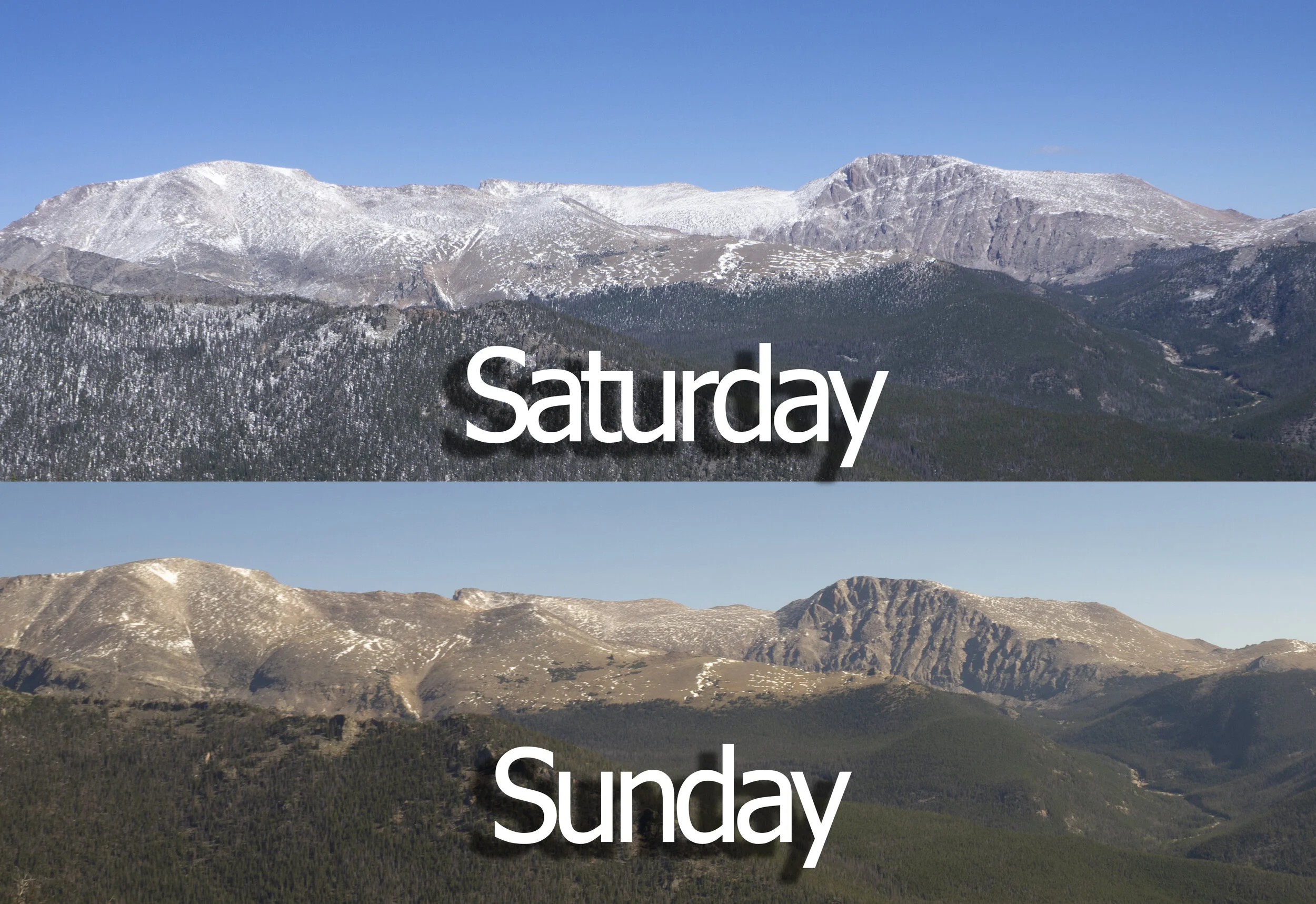
On our second day entering the park we were excited to see that Trail Ridge Road had been opened overnight. There wasn’t much question as to where to head off to. We stopped again at Rainbow Curve Lookout and were amazed at how much 24 hours changed the landscape. The weather had been improving since we had arrived in the area and a good portion of the snow on top of the mountains surrounding the lookout had now melted.

Continuing on Trail Ridge is a climb. The road is wider than a lot of Colorado mountain roads so it wasn’t overly intimidating, but still an experience. There are many pull offs to take in the amazing views of all the surrounding mountains.


The Tundra - highest point in Rocky Mt National Park


This section of the road is above the tree line and where the name Rocky Mountains comes from becomes apparent. This makes the views unobstructed and incredible. At this elevation, the snow rarely melts on the peaks, even with the weather starting to feel more like summer again. Just like the previous night, we couldn’t have gotten a clearer sky.


At about 12,000 feet lies the Alpine Visitors Center. This is pretty much the point on Trail Ridge Road where you start to descend. In these steep Rocky Mountains, coming down the mountain is a bit touchier than climbing. It’s quicker though.

Since we weren’t going back to Estes Park we decided to continue on out of the west side of the park and on to Grand Lake. On the way we made a quick stop at Lake Irene for a bite to eat.

Lake Irene

Once the land flattens out it’s pretty much a straight shot down. Grand Lake was the first time the severe drought showed it’s effects. This wasn’t the worst we would see, but the water level drop was pretty dramatic compared to the lakes we had seen up to this point.


Shadow Lake
On the way out of the park we passed this small historical area with a building. Everything was closed up due to Covid so we couldn’t explore the historical significance of the area but we did stop to at least get a picture.
